A Necessary Utility: Scott County Water Towers

By Charles Pederson, Guest Blogger

Are they giant Martians, marching with their spiderlike legs across the countryside? No! They’re water towers. Once you notice one, you begin to see them everywhere, especially in the Midwest. Greg DiLoreto, past president of the American Society of Civil Engineers, commented that the flatness of the landscape lends itself to water tower usage. “Elsewhere, we have reservoirs, but they’re tanks that are up in the hills.”

Most water towers are administered by municipalities (towns, cities), though many companies or other organizations (3M in Saint Paul or Eaton in Eden Prairie come to mind) have their own water sources. Depending on size, most municipalities have one or more—sometimes many more. Shakopee, for example has five water towers and three in-ground storage tanks.

Water Tower Basics

The concept of storing water for later use is ancient. The ancient Romans, for example, used the impluvium, a cistern-like basin, to catch rainwater and store it beneath a house.

The idea of water towers, however, goes back to the later 19th century. Early wooden structures gave way to modern building materials including concrete, metal, and other materials.

Wood was a common building material used for early water towers, such as this reservoir used to refill the boilers of steam trains. (Photo courtesy of Scott County Historical Society.)

Water towers, water tanks, and other reservoirs serve two purposes: first, to store water and, second, to distribute water by creating water pressure within a pipe system. Water towers are placed in strategic water pressure zones, each serving a given number of homes in an area. The tower is located at the highest place in a zone, reducing, according to Tony Myers of the Shakopee Public Utilities Commission (SPU) “the overall cost of the water tower as it does not have to be constructed as high to achieve the desired water pressure.” Correct placement also ensures consistent water pressure even at moments of heavy use. The pressure uses gravity to push that water through large pipes that branch off into smaller and smaller pipes until they finally enter your home. You’ve seen the effect: you turn on a faucet, and water comes out. Thank you, Local Water Tower!

The first water tower in Shakopee was constructed in the 1920s, according to Myers, and was among the first in Scott County. It was a standpipe (exactly what it sounds like: a tall pipe with water inside it) at Holmes Street and Shakopee Avenue.

A standpipe from ca. 1910 stood at the northern edge of Gustavus Adophus College in Saint Peter, providing water pressure for the campus and town. (Photo courtesy of Nicollet County Historical Society.)

As of 2022, Minnesota had 1,056 water towers, according to the very helpful Minnesota Water Towers (MWT) website. Scott County alone boasts about 20 water towers, along with additional in-ground storage tanks. Said Myers, “The average water tower costs between 2 and 5 million dollars to construct and between $750,000 and 2 million dollars to repaint.”

Types of Water Towers

The MWT website counts 11 different types of water towers. Most fit into a few categories: standpipes, cylinders with a round or flat top, spheres or spheroids, and short or tall reservoirs. Water towers can have a single central pillar or several legs supporting them.

The most common type of water tower in Minnesota (at a total of 335) is the one-thin-leg­-with-round-top type, sometimes called a watersphere. These golf-ball-on-a-tee-shaped water towers can be found on the Shakopee Mdewakanton tribal lands (SMSC) near Prior Lake, as well as in Belle Plaine, Savage, Elko New Market, and New Prague. Most modern towers can hold in the hundreds of thousands, or even millions, of gallons of water.

Waterspheres are popular types of water towers, such as the water tower at Belle Plaine. (Photo courtesy of SCHS.)

The average age of tee-shaped water towers is 28 years. Constructed in 1940, the tower, located near the Shakopee community center, is certainly among the oldest currently standing in Scott County. At 130 feet in height and a capacity of 250,000 gallons, it was hailed as an engineering breakthrough. It greatly increased local water capacity, its spherical construction reduced wind resistance, and its steel plates were welded rather than riveted for strength and lightweight performance. It replaced the earlier Shakopee standpipe.

Scott County Water Towers

We couldn’t find definitive historical information on water towers for all Scott County towns, but we were able to dig up some other interesting information.

Belle Plaine

Downtown Belle Plaine, 1896 (Image courtesy of the Scott County Historical Society).

An 1896 photo (above), apart from looking quaint and old-timey, shows off Belle Plaine’s “giraffe” water tower, so called because it was considered a monstrosity. The giraffe replaced a town well, located in the center of town, which had been used mainly for fighting fires. A special election was required in late 1907 to replace the giraffe with a new steel water tower—capacity 50,000 gallons. It cost $8,786 (around $300,000 today).

Jordan

Jordan water tower photographed by LeRoy Lebens, c. 1975-1985 (Image courtesty of SCHS).

The Jordan Independent reported on a near-fatality when a newly constructed water tower was painted in the 1970s. “Tragedy almost struck when a worker fell while painting a leg on the tower.” It’s unclear whether he was injured.

New Prague

Main Street looking east, New Prague, Minnesota (Image courtesy of the New Prague Area Historical Society).

New Prague water tower photographed by LeRoy Lebens, c. 1965-1975 (Image courtesy of the Scott County Historical Society).

A 1900-era photo of New Prague’s Main Street (top) includes a view of the water tower. The land had been donated by local Elias Bruzek. A 1970s-era photo shows a newer, 300,000-gallon water tower. The Jordan Independent reported that “a 22-year-old painter from Stephen, Minn., died [when he] fell 90 feet off the New Prague water tower.”

Prior Lake

Prior Lake water tower, 1973 (Image courtesy of the Scott County Historical Society).

A wooden water tower from ca. 1875 (top) was located at the edge of Prior Lake. The Scott County Historical Society in Shakopee displays an 18-foot-long board from that tower. A 1973 photo depicts a later downtown cone-hat water tower on Main Street. The current 750,000-gallon tower was constructed in 1973 and repainted about 20 years later at a cost of $790,000.

Savage

(Image courtesy of the City of Savage)

Photographed in the mid-1960s, the first Savage water tower stood near city hall. The tower was demolished in 2000.

Shakopee

(Image courtesy of the Scott County Historical Society).

The spherical tower near the Shakopee Community Center was constructed in 1940. A sign at the tower’s base proclaimed that the tower was 130 feet tall with a 42-foot “ball.” The April 1, 1940, Shakopee Argus claimed that it was the world’s tallest of its kind. Filling the 250,000-gallon reservoir took all night and then some. The letters in the word Shakopee were more than four and half feet tall, with the entire word coming in at 28 feet long. In September 1940, the Argus noted that, when the water was released into the city water mains, the sudden increase in water pressure caused some bursting of home water pipes. A major rupture in the mains occurred at the Rock Spring bottling company downtown.

Shakopee Water

Tony Myers of SPU provided more specific information about Shakopee’s water. SPU began in 1951 as a nonpartisan organization operating with qualified experts to maximize efficiency in the water utilities.

·         Shakopee maintains five water towers and three ground tanks located in three pressure zones.

·         Shakopee relies on four wells for water supply. The wells draw from three aquifers, which hold underground water: Jordan, Tunnel City Wonewok, and Mount Simon Hinkley.

·         Over 20 miles of water pipes crisscross the city.

·         Approximately 300,000 gallons of water are pumped daily.

·         Shakopee maintains 500 fire hydrants.

·         New water towers are constructed as development occurs in an area, increasing water demand.

·         Aquifer levels are monitored daily. A critically low level has not yet been reached. “Since SPU’s wells are spread throughout the city,” said Myers, “we have the ability to alternate which wells run, as not to significantly impact the aquifer levels in an area of town.”

·         Water is constantly tested for contamination. If contamination were detected, wells and towers could be isolated from the system without interrupting the provision of safe drinking water.

Aquifer Primer

To have a well, you need an aquifer—a layer of underground permeable or porous rock, sand, or gravel deposit that can hold water. Sandier, looser deposits typically refill faster than clayey deposits. In eastern and northeastern Scott County, especially along the Minnesota River, the fastest recharge rates are found. Central and southern areas consist of more clay-like deposits. Dale Setterholm in the Geologic Atlas User’s Guide likens an aquifer to a bank account. Water coming in is like income, and water pumped out is like spending. When more water is pumped out than comes in, the level falls. “This is like spending money faster than your income provides it,” says Setterholm. “Your bank account shrinks.” Aquifers are refilled through infiltration (movement of water from surface to aquifer) or recharge (movement of water below the surface).

Water falls to Earth’s surface and infiltrates the underground layers to refill aquifers (Courtesy of Geologic Atlas User’s Guide).

Aquifers are often sandwiched between moisture-resistant underground layers called aquitards (Courtesy of Geologic Atlas User’s Guide).

For assistance with this article, many thanks to Diana Brenke of the Jordan Area Historical Society, Emily Gunderson of the City of Savage, and Tony Myers of the SPU. If you have more information on water towers in Scott County, we’d love to hear about it. Contact us via either our Facebook page (https://www.facebook.com/SCHSHistory) or our email address (info@scottcountyhistory.org).

Learn More!

Henderson [KY] Water Utility. (n.d.). Why Do We Have Water Towers? Retrieved from https://web.archive.org/web/20210722182032/https://www.hkywater.org/education/i-didnt-know-that/why-water-towers

Minnesota Department of Natural Resources. (2021, March). Groundwater Atlas User Guide. https://files.dnr.state.mn.us/waters/groundwater_section/mapping/groundwater-atlas-user-guide.pdf

Minnesota Water Towers. (2022). [Home Page]. https://www.minnesotawatertowers.com/home

National Geographic. (n.d.). Aquifers. https://education.nationalgeographic.org/resource/aquifers/

Reinan, John. (2019, November 2). Why Do We Have Water Towers and What Do They Do? https://www.startribune.com/why-are-there-so-many-water-towers-in-minnesota-and-what-do-they-do/563803581/

Scott County (MN). (2006). Subsurface Recharge and Surface Infiltration. https://www.google.com/url?sa=t&source=web&rct=j&opi=89978449&url=https://www.scottcountymn.gov/DocumentCenter/View/989/Plate-6-Subsurface-Recharge-and-Surface-Infiltration-PDF&ved=2ahUKEwiryc-Lx4qFAxV6E0QIHbGeAVkQFnoECA8QAQ&usg=AOvVaw0R8yDSABT9i4DMJvMwWaPh

Setterholm, Dale R., & Tipping, Robert G. (2006). Plate 6, Subsurface Recharge and Surface Infiltration. In Geologic Atlas of Scott County, Minnesota. https://hdl.handle.net/11299/58717

Setterholm, Dale R. (2019). Geologic Atlas User’s Guide. https://conservancy.umn.edu/bitstream/handle/11299/166713/CGA_users_guide2019.pdf?sequence=12&isAllowed=y

Staff Report. (2023, March 2). Plans Finalized for Water Tower [Jordan] Repaint. https://www.swnewsmedia.com/jordan_independent/plans-finalized-for-water-tower-repaint/article_5a6f526c-b451-11ed-9200-d7d64acd84ec.html

SWnewsmedia. (2020, Jan 23). 50 Years Ago: Jordan Water Tower Constructed. https://www.swnewsmedia.com/jordan_independent/news/local/looking_back/50-years-ago-jordan-water-tower-constructed/article_0c92145d-9274-5516-ab5d-df1ba12d2666.html

Wikipedia. (n.d.) Water Tower. Accessed January 31, 2024: https://en.wikipedia.org/wiki/Water_tower


The Shakopee Tornado of 1977

By Jacob Dalland

It’s not often that Shakopee gets tornadoes. It’s even less often that a tornado strikes the business district, or downtown, of a city. However, on May 21st, 1977, one of the most notable tornadoes in Scott County history struck the heart of Shakopee and left much damage in Shakopee neighborhoods, mostly by destroying trees.

These two photos from Shakopee Valley News show two damage scenes: an uprooted tree (left) and a destroyed storage shed (on right).

The tornado began just north of Heidelburg in Le Sueur County. It tracked northeast from there. The whole track until Shakopee was all through farmland, though the tornado got close to both New Prague and Jordan. That being said, the damage must have been quite minimal in the countryside, for neither the New Prague Times nor the Jordan Independent mentioned any tornado in their next editions.

Shakopee, however, was different. Although no one was killed or even injured, the tornado tore out many trees and ruined a few buildings, sometimes due to toppled trees. The path through Shakopee began roughly where the new Shakopee High School is today and ended at Huber Park on the Minnesota River. There was plenty of damage, but some of the large buildings that were damaged by a previous tornado in 1925 (such as St. Mark’s Catholic Church) were apparently spared this time, despite being affected by both storms.

The tornado uprooted a large portion of trees on Shakopee's streets. Lawns were sometimes pulled up like thick carpets with the trees. Photo from the Shakopee Valley News.

Although the tornado of 1977 was not as strong as the one in 1925, it nonetheless left a noticeable blemish on the streets of Shakopee for years to come. In comparing aerial photographs of Shakopee from 1970 and 1980, you can see the decrease in the number of trees in the image from 1980, 3 years after the tornado hit. You might also notice the expansion of Shakopee’s suburban neighborhoods as well.

Overall, the tornado that struck Shakopee in 1977 might not have been Shakopee’s worst tornado, but it was a memorable one nonetheless. It was the first one to strike downtown Shakopee since 1925, and the last one up to now. The lesson to be learned is: know how to stay safe during severe weather if you live in Shakopee (or anywhere in Scott County, for that matter), for whether you remember a tornado in your lifetime or not, the city of Shakopee remembers.

References:

ArcGIS. “Tornado Paths”. Accessed March 19, 2024. https://www.arcgis.com/apps/View/index.html?appid=01672085b139432e8fe1296a743f67d7.

Holtz, Kristin. “Are We Tornado Safe?” Shakopee Valley News, April 19, 2012, p. 1.

“ScottGIS3”. Scott County | Minnesota. Accessed March 19, 2024. https://gis.co.scott.mn.us/sg3/.

Shakopee Valley News, May 25, 1977, p. 1.

The Tornado of 1925

By Jacob Dalland

On June 2nd, 1925, Scott County found itself on the edge of a strong tornado. Although the damage was mainly in Carver and Hennepin counties, Shakopee especially had enough damage from the storm to be considered the most severe tornado damage in Shakopee history.

The tornado was part of a larger severe thunderstorm that swept through both sides of the Minnesota River in Carver, Scott, and Hennepin counties. The severe weather that evening concluded a heat wave, as many severe thunderstorms do; Memorial Day was the hottest in many years at over 94 degrees. The day of the tornado was nonetheless pleasant until the storm started. Many people were outside eating their suppers at picnics before the storm started.

Just before 7 p.m., the sky started getting dark with storm clouds. The severe weather caught many people off-guard. However, those outside were for the most part able to find shelter quickly. Blakeley residents were the first in Scott County to be hit with damaging winds, which damaged or destroyed many barns and trees, but no lives were lost. Similar damage happened in Belle Plaine, though a horse and a calf were killed. Minimal damage was done in Jordan.

The tornado itself apparently touched down somewhere between Belle Plaine and Carver at 7 p.m. Three people were killed in Carver who were out picnicking at the park and had a tree fall on the pavilion they took shelter in. The tornado soon moved into Chaska. No deaths occurred there, but many buildings were damaged. Guardian Angels School, for example, had most of its rear wall destroyed (which meant eighth graders didn’t have to take a high school entrance exam)!

Shakopee was, apparently, just on the edge of the tornado. Logically, the western side of town was hit the hardest. The Mudcura Sanitarium, on that same side, received special attention in the Shakopee Tribune. A few garages were destroyed by the storm on the sanitarium grounds. Dr. Fischer, who ran the sanitarium, broke his arm when the wind slammed a door on him. His assistant, Larry Hunter, was injured in the same way. One of the hardest-hit places in Shakopee was St. Mark’s Catholic Church: the steeple’s cross was torn off, and so was one of the spires, which resulted in damage to the interior of the church. Many houses and buildings in downtown Shakopee had moderate damage. That being said, no deaths occurred in Shakopee, and most of the damages were covered by insurance (including that at St. Mark’s).

The tornado proceeded on through farmland in Chanhassen, Eden Prairie, and Minnetonka before ravaging one more town: Hopkins. Although only one death happened there, more buildings were destroyed there than in Carver, Chaska, or Shakopee. For example, a Moline warehouse was reduced to pieces as well as a historic schoolhouse from 1862 (whose fate was being debated before the tornado happened). After a brief entry into St. Louis Park, the tornado finally dissipated.

Overall, the tornado of June 2nd, 1925 is arguably the most historic tornado in Scott County history and even more significant for places in Carver and Hennepin Counties. While there were some strong tornadoes (EF-2) in 1952 and 1977, the one in 1925 appears to be the one most remembered by the communities it hit. This could be because of the level of damage. Mary Raabe, of the Hopkins Historical Society, wrote that “it could easily be a stage three tornado by today's standards”, probably meaning to say it would be classified as an EF-3 tornado. Based on my own comparison of the reported damage and the damage criteria for an EF-3 tornado, she is likely correct.

References

Barac, LaVonne E. Chaska: A Minnesota River City, Prehistory to 1950. Chaska: Chaska Historical Society, 2019.

Hopkins Historical Society. Hopkins, Minnesota: Through the Years, edited by Beverly O. Ewing. Hopkins: Hopkins Historical Society, 2002.

“Local Weather Highlights”. St. Louis Park Historical Society. Accessed March 15, 2024. https://slphistory.org/weather/.

Olson, Mark. “Look Back”. SW News Media. Accessed March 15, 2024. https://www.swnewsmedia.com/look-back/image_9f89e970-fcf8-5a97-9626-45fa27e95b5c.html.

Raabe, Mary. “June 2nd, 1925”. Hopkins Historical Society. Accessed March 15, 2024. https://www.hopkinshistory.org/tornado-of-1925.html.

“Scott County Escapes a Tornado’s Worst”. Jordan Independent, June 4, 1925, p. 1.

Stolzman, William F. A History of the Church of St. Mark, Shakopee, MN, 1856-2006. Unpublished, 2007.

“Three Killed in Storm at Carver – Many Barns Wrecked in This Section”. Belle Plaine Herald, June 4, 1925, p. 1.

“Tornado Kills Three at Carver”. Shakopee Tribune, June 4, 1925, p. 1.

The Solar Eclipse of 1954

by Jacob Dalland

Total solar eclipses are always an amazing and memorable phenomenon to witness, and millions travel to see them. Some of you are most likely traveling to see the one coming soon on April 8th. However, Scott County residents and many other Minnesotans did not have to travel at all to see the one that happened on June 30th, 1954, and perhaps some of you remember that one.

That day, the Moon’s shadow started its race across the globe in Nebraska, where the Sun rose dark. Indeed, all who were living in the American part of the path had to get up early to see the eclipse at totality (that is, when the Moon covered the entire Sun). The Moon’s shadow moved northeast across parts of South Dakota and Iowa before entering Minnesota.

This photo featured in Shakopee Valley News shows a sequence of images from the solar eclipse.

Many Scott County residents did indeed get up early to see the eclipse. It was a clear and comfortably cool morning (Minneapolis was at 62 °F at the time, according to weather almanacs). Some got in their cars and went to high ground to get a good view of the Sun low on the horizon. Smoked glass and negative film were apparently the most common materials people used to observe the eclipse’s progress. Lots of photographers brought out their cameras as well to capture the moment in both black-and-white and color photos as well as some movies.

A photo of a solar eclipse from Leroy Lebens' collection. Unless Leroy traveled for a different eclipse, this photo is likely from the June 30, 1954 solar eclipse.

Totality lasted around two minutes. Some observers in Jordan even timed the length of totality with a stopwatch. Overall, Scott County residents got to experience “nature’s top show”, as the New Prague Times put it. As happens today, visitors from far outside the eclipse path came to see the event.

The total solar eclipse of 1954 was the first “since the white man came to Shakopee”, as the Shakopee Tribune put it. Indeed, the last total solar eclipse in today’s Scott County that happened before 1954 would have been in 1205, which indigenous peoples would have seen assuming the sky was clear. The next total solar eclipse in Scott County will be in 2099; perhaps some young readers will see that one.

Shakopee residents watch the eclipse in progress through smoked glass and other methods of sunlight filtration, while others pose for the camera.

In general, the total solar eclipse of June 30, 1954 was observed under great conditions and became a fun memory for all who saw it. So went the first total solar eclipse in this area’s recorded history.

References

Espenak, Fred. “JavaScript Solar Eclipse Explorer for North America”. Eclipsewise.com: Predictions for Solar and Lunar Eclipses. Last modified January 17, 2015. https://eclipsewise.com/solar/JSEX/JSEX-NA.html.

Espenak, Fred. “Solar Eclipse Prime Page: Solar Eclipse of 1954 Jun 30”. Eclipsewise.com: Predictions for Solar and Lunar Eclipses. Last modified March 3, 2022. https://eclipsewise.com/solar/SEprime/1901-2000/SE1954Jun30Tprime.html.

“Fort Snelling, MN Weather History”. Weather Underground. Accessed March 12, 2024. https://www.wunderground.com/history/daily/us/mn/minneapolis/KMSP/date/1954-6-30.

Lebens, Leroy. “Solar Eclipse Copy” (photograph). Negative film. 2017.020.8697.

“Perfect Weather at Jordan for Great Solar Eclipse”. Jordan Independent, July 1, 1954, p. 1.

“This Area Treated to Total Eclipse Yesterday Morning”. New Prague Times, July 1, 1954, p. 1.

“This Is What They Saw”. Shakopee Valley News, July 1, 1954, p. 1.

The "Boiling Springs" of Savage

by Jacob Dalland

In a not-so-busy part of Savage, Minnesota, Eagle Creek widens out into an almost circular pool. A visitor’s first impression might be that it is a peaceful and quiet place, where Eagle Creek almost seems to rest before moving onward to its mouth on the Minnesota River. If by chance, however, a visitor comes at the right time or sticks around long enough, the water will ripple, gurgle, and even shoot upward a few feet. This is not a geyser, but a unique Maka Yusota, or otherwise known by English-speakers as Boiling Springs.

Maka Yusota is a Dakota phrase, coming from the word for “earth” (maka) and “to make muddy or roil up” (yusota). For centuries, the Dakota people have revered this as a sacred place, where the water spirit Unktehi resides. One oral tradition has it that Eagle Creek got its name from when an eagle flew out from the springs and turned into Buffalo Calf Woman, who guided the Dakota people also from the springs with the Sacred Pipe. The Dakota leader, Eagle Head had a village here for many years, and was formally vacated in 1853 as part of the 1851 treaty at Mendota. Apart from the exodus story in the Dakota oral traditions, Maka Yusota has also had sacred significance as a kind of oracle. One story tells of how in 1858 a warrior came to the springs and speared one of twelve lumps of earth pushed up to the water’s surface, which immediately seemed to bleed. This was interpreted to signify an imminent battle. The Battle of Shakopee, fought between the Dakotas and Ojibwes, occurred soon afterward.

By the time the Battle of Shakopee happened, the Dakota people no longer had the exclusive right to live on the land, and farmers were soon homesteading in the area. A French grape farmer briefly owned the land first in the early 1850s in what was then Glendale Township. In 1855, Gregor Hattenberger bought the farm and improved upon the grape vineyard. He also built and operated a grist mill and made wine from the grapes. A farmhouse was built only about 300 feet feet from the springs in the 1870s.

A close-up image of Boiling Springs in action, from a postcard in the 1910s. Scott County Historical Society.

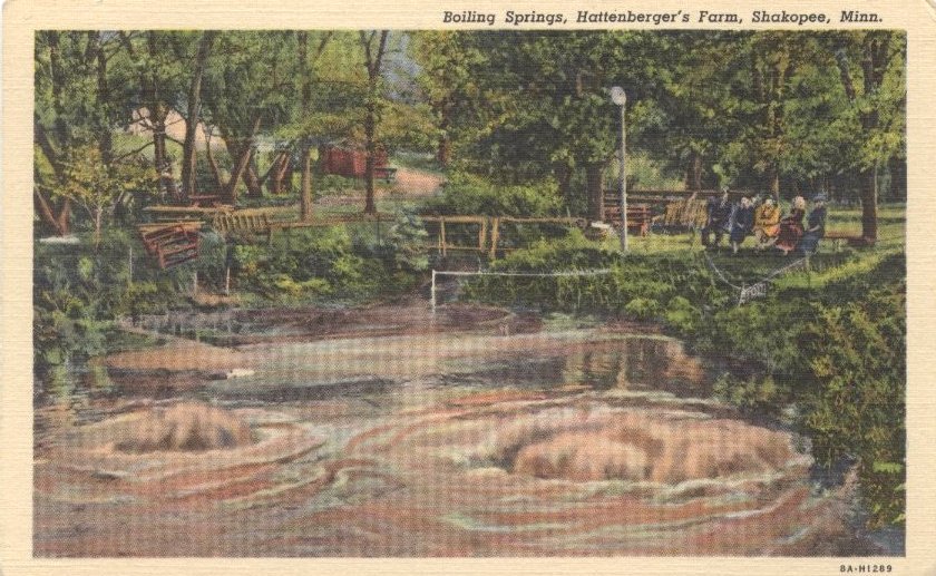
The Hattenberger family, knowing that the Boiling Springs were not only sacred to the Dakotas but also unusual in their own right, soon opened up that part of their property to visitors of all backgrounds. By the turn of the century, Boiling Springs was essentially a privately owned park. Trees were cleared to make a trail and a picnic grounds, and visitors could watch the springs bubble from behind a fence. Back then, the springs bubbled constantly rather than sporadically. Before the fence was put up, an occasional cow or horse would die from sinking in the quicksand of the springs. The way the springs “boil” is thought to be from sand settling at the bottom, clogging the opening of the springs, and then erupting upward after the water pressure of the springs is great enough. Then the process would repeat.

This color postcard shows how park-like Boiling Springs used to be. Despite being located in Glendale Township (now Savage), postcards often mislabeled the location as Shakopee. Scott County Historical Society.

The heyday of tourism at Boiling Springs seems to have been the first half of the 20th century. Photographic postcards of Boiling Springs were being made and sold in the 1910s especially. Every now and then, articles advertising Boiling Springs as a “natural wonder” would appear in local newspapers. Three generations of Hattenbergers hosted visitors to the site: Gregor, Alexander, and Alois. The Hattenbergers offered homemade wine, replaced by ice cream and candy in the ‘20s through ‘40s.

After Alois Hattenberger died in 1953, his cousin Herb Hirscher ran the farm and continued to provide hospitality to visitors. During the Hirscher years, the springs started to quiet down, possibly due to a lower water table. Therefore, the springs started to lose attention, though people could picnic there as late as 1959. Dakota pilgrims never ceased to visit during the Hirscher years, either. That being said, tourism was definitely on the decline at Boiling Springs from the ‘60s through ‘80s. The Hirschers commented in 1985 that Boilling Springs “was lovely in its day.”  Herb died in 1986, leaving his wife to run the farm for a time. The Hirschers hoped that after they were gone, Boiling Springs would be preserved by the Minnesota Historical Society or some other public entity.

The Hirschers’ and more importantly the Dakota people’s hopes of conserving Boiling Springs were put to the test in 1994. That year, Lucille Hirscher sold her farm to Klaas van Zee, a developer for the City of Savage. Almost immediately, a struggle ensued between members of the Shakopee Mdewakanton Sioux Community and environmental advocates on one side and real estate developers on the other. There was a very real threat that the construction of a new suburban neighborhood on the site would not only ruin Boiling Springs and the Dakota burial sites around it, but also threaten the habitat of brown trout (whose Eagle Creek habitat was one of the last in the Twin Cities) and many other animals. After a year of petitions and debates, the two sides essentially compromised. The City of Savage was allowed to build a suburban neighborhood on some of the former Hirscher farm, but the Minnesota Department of Natural Resources bought all the land within 200 feet of Eagle Creek to preserve as an Aquatic Management Area. The old farmhouse was unfortunately outside of this zone, and was subjected to a deliberate burn to test new firefighting equipment in 1997. Boiling Springs, on the other hand, continues to be conserved in its natural state by the DNR and has been listed on the National Register of Historic Places since 2003.

Today, Boiling Springs lies within a grove of trees, almost concealed from the view of the houses nearby. Apart from minor trails made by the tread of occasional visitors’ feet, nobody would ever know the springs were widely visited in the past. Maka Yusota, Boiling Springs, is nonetheless one of the most significant places in all of Scott County.

References

Bloomberg, Britta. “Recent Additions to the National Register of Historic Places”. Minnesota Preservation Planner 14, no. 2 (Spring 2003): 2.

“Boiling Springs” (postcard).

“Boiling Springs, Hattenberger’s Farm, Shakopee, Minn.” (postcard).

“Boiling Springs Natural Wonder”. Shakopee Tribune, November 5, 1925, 3.

“Boiling Springs, Natural Wonder of Area, Reopened for Picnickers”. Shakopee Valley News, June 18, 1959, p. 1.

“Boiling Springs Near Shakopee Termed Unusual Phenomenon”. New Prague Times, November 25, 1925, p. 1.

Brewer, Joseph W., to Heald, John. “Comment Statement: Alternative Urban Areawide Review for Savage Fen, Eagle Creek, and Boiling Springs Development”. November 7, 1994.

Durand, Paul. Where the Waters Gather and the Rivers Meet: An Atlas of the Eastern Sioux. Faribault: Paul Durand, 1994, 44.

“Hattenberger Rites Monday”. Shakopee Argus Tribune, September 10, 1953, p. 1.

“Herbert A. Hirscher”. Shakopee Valley News, July 2, 1986, p. 6.

Hirscher, Herb and Lucille. “Boiling Springs”. In As I Remember Scott County, 1980.

Kaszuba, Mike. “Old Farmhouse in Savage Runs out of Time – and Luck”. Star Tribune, November 30, 1997, p. B1.

“Remember When...” Savage Pacer, February 19, 2005, p. 5.

Shakopee Mdewakanton Sioux Community. “MA-KA YU-SO-TA (Boiling Springs)”. September 2000.

Simonson, Beverly. “Savage Woods Once Echoed with Sounds of Legendary Springs”. Prior Lake American, October 19, 1977, p. 3.